• Home
  • Town Government
    • Committees & Commissions
    • Highway Department
    • Hours and Officers
    • Selectmen
    • Town Clerk/Taxes
  • Groups & Organizations
  • Safety Services
  • Community Services
    • Bath Public Library
    • Bath Village School
  • History/Covered Bridges
  • Home
  • Town Government
    • Committees & Commissions
    • Highway Department
    • Hours and Officers
    • Selectmen
    • Town Clerk/Taxes
  • Groups & Organizations
  • Safety Services
  • Community Services
    • Bath Public Library
    • Bath Village School
  • History/Covered Bridges
  Bath, NH

The history of bath

Bath: A Short History


The first recorded exploration by the Colonial Government of what is now Bath occurred in late July and August of 1754. Captain Peter Powers and company crossed the Ammonoosuc River at its mouth on July 28, traveled up the Ammonoosuc, and proceeded north through what is now West Bath . They returned by the same route a few days later.  

Bath was originally charted in 1761 and rechartered in 1765 and contained a little less than six square miles. The first town meeting was in 1784. Initial settlement took place along the Ammonoosuc andConnecticut Rivers , and the first settlers were subsistence farmers who produced nearly everything needed for food, clothing and shelter. The earliest houses in Bath were log cabins. However, none of these are known to remain. Soon the center of activity shifted to West Bath and the first meeting house in town was erected there in 1792. By the early nineteenth century Bath Village had become the social, political, and industrial center of town.  

The first industries supported the rural way of life with blacksmith shops for making horseshoes and nails, wheelwrights building and repairing wagons and sleighs, gristmills for grinding wheat into flour; and sawmills preparing lumber for building. Barter was the "coin of the realm," and taxes assessed for roads were paid by working on the roads. Produce was hauled to Boston by horses or shipped toHartford via the Connecticut River and traded for what could not be produced locally.  

Bath is divided into Bath Village , Upper Village , Swiftwater, Carbee, Getchell, West Bath , Pettyboro, and Nutter Districts. Originally 13 schools were distributed through the town, and each district had, to varying degrees, other institutions, churches, and businesses. Water power provided by the Ammonoosuc and Wild Ammonoosuc Rivers , as well as many of the smaller streams, drove the early mills and other industry. Bath Village and Swiftwater were the commercial engines of the town. Industries included a woolen factory, a creamery, a distillery, and at least two factories that made starch from potatoes. The practice of jurisprudence was important to the town through the nineteenth century. Logs were floated down the Ammonoosuc, Wild Ammonoosuc, and Connecticut Rivers to mills in the town and beyond. Mining of various minerals flourished briefly. With the coming of the railroad in 1850, "going below" became quicker and easier.  

Bath has evolved with the passing of time and shifting economic and demographic patterns. While Bath Village center remains the focus of the town, both socially and economically, a variety of moderate and small businesses are now found throughout the town. Agriculture and forestry remain important. Only one business in the town now relies on water power. Fundamental Solutions, Inc., located in the old leatherboard mill, generates electricity by waterpower that it sells along with a variety of other products. Canoes, kayaks, and tubes are the major users of waterpower in the town today.  

Electricity and the internal combustion engine have replaced waterpower and beasts of burden, and the railroad has come and gone. Improved roads and more reliable year round transportation have played a role in the development of the town. Education has been centralized, and nonagrarian residential development has spread. Bath once supported 13 Schools. Today the Bath School , located in the village, teaches grades K-6. Most of the older students continue their schooling at Lisbon or Woodsville. Twelve cemeteries once served the town. While only five of these continue in active use, all save one whose exact location is lost to time are maintained by the town and provide vivid windows into the past settlement and decentralized character of Bath .  

Population peaked in the early 19th century (1,623 in 1830) and the trend was a decline in residents through the late 20th century (604). This trend has reversed and the population of Bath has shown a steady increase. Bath is no longer a farming/industrial/judicial center, but is becoming a bedroom community for the nearby towns of Littleton and Haverhill .

Covered Bridges

Bath Bridge
Picture
Picture
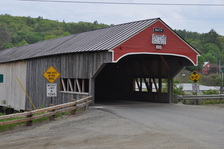
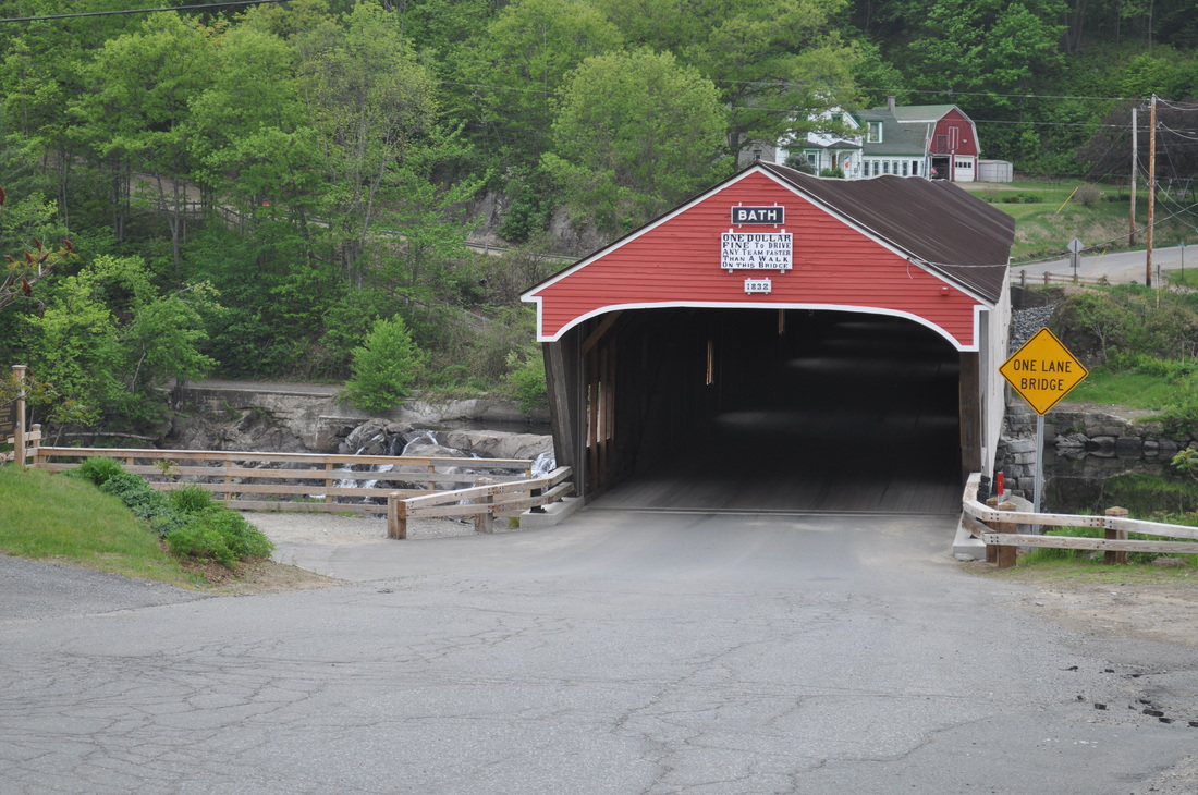
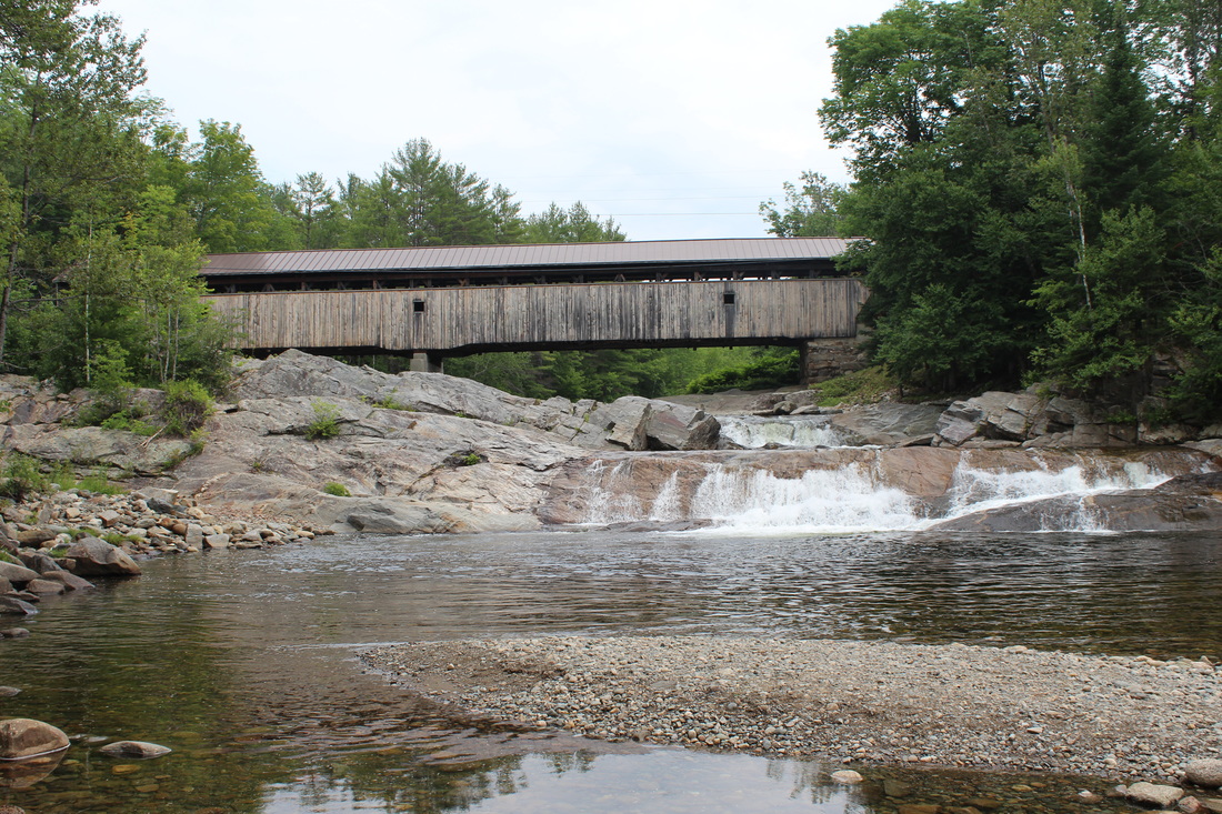
The Bath Covered Bridge in the center of Bath Village connects Route 302/10 to West Bath Road and Pettyboro Road.   The current structure is the fifth bridge to stand on this site. The first was constructed in 1794 at a cost of $366.66. That bridge was demolished by a flood and replaced in 1806 at a cost of $1,000. The second and third bridges were also destroyed by floods but immediately replaced in 1820 and again in 1824. The fourth bridge was destroyed by fire in late 1830. Rebuilding efforts began in March 1831 when $1,400 was allotted to cover the construction of two stone abutments and piers along with the purchase of other materials. In March 1832, an additional $1,500 was allotted to complete the construction. It appears that the fifth bridge was completed by early 1832. When it was first built, the bridge had hewn arches. New overlapping arches were added when the bridge was raised over the railroad in 1920. At one time, there was a sign posted at the bridge which prohibited riding horses across the bridge at a trot. It was believed that the impact of trotting horses could cause the structure to fall apart.  The Bath Bridge underwent major renovations from       
The Bath Bridge is listed on the National Register of Historic Places.


Bath-Haverhill Bridge
Picture
Picture
Picture
Picture
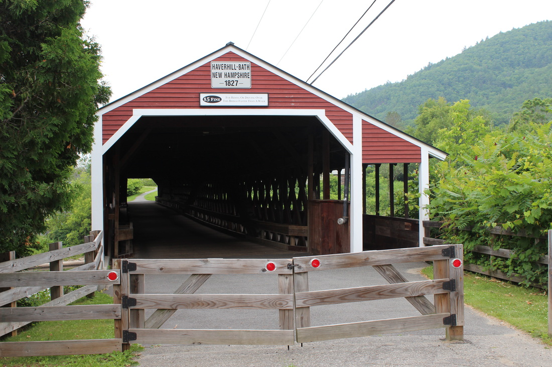
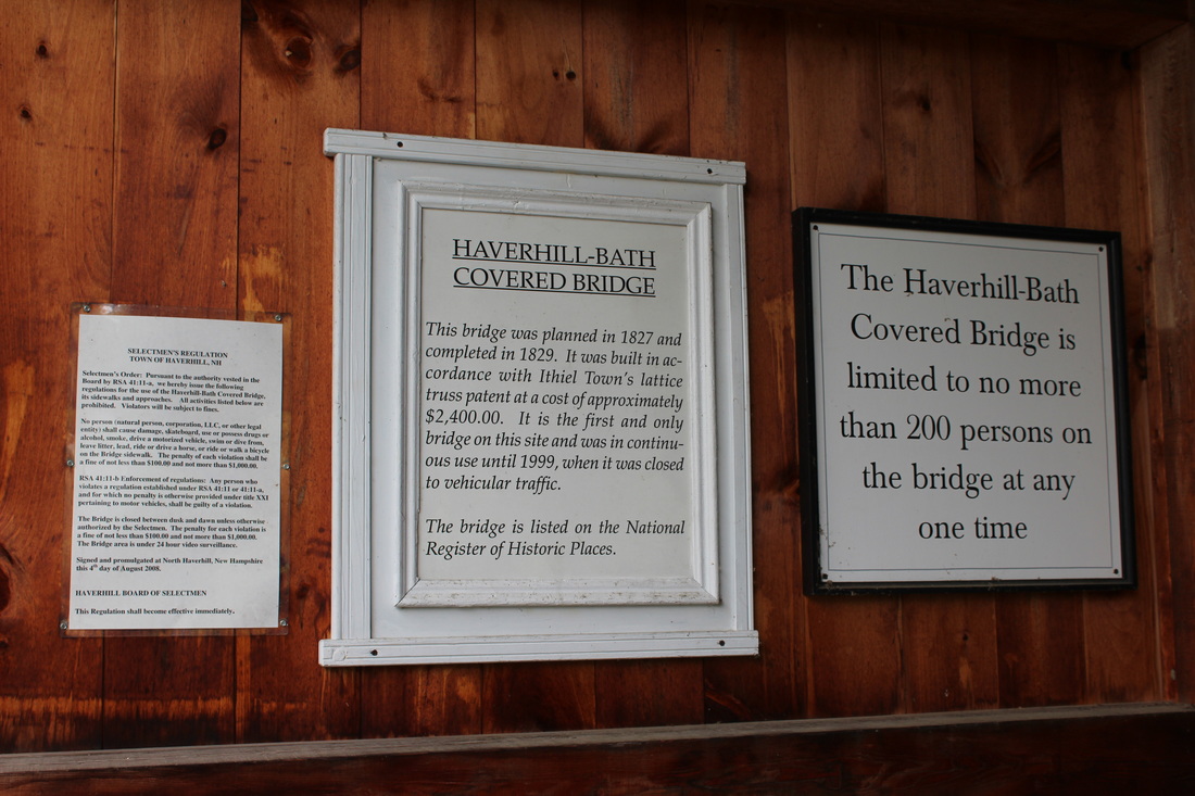
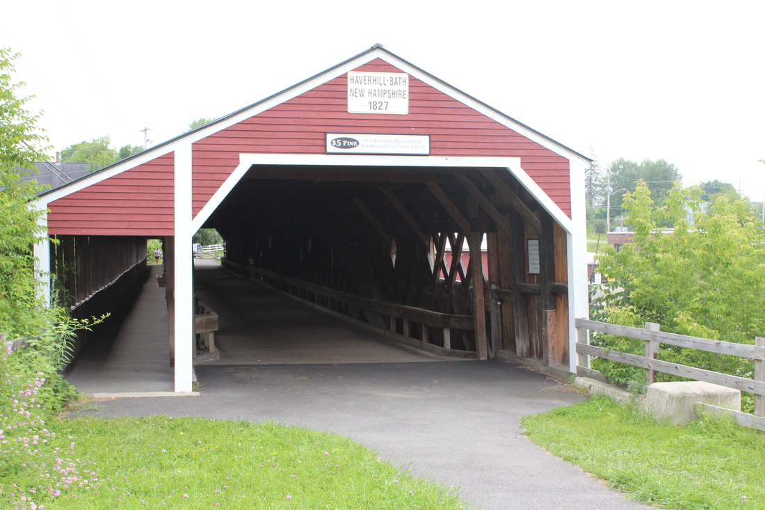
The Bath-Haverhill Bridge is located in Woodsville Village on Route 135 over the Ammonoosuc River.  According to New Hampshire Department of Transportation records, this is the oldest covered bridge in New Hampshire. It is the first and only bridge to be erected at this site. In March of 1827 the voters of Bath appointed a committee to hold discussions with the selectmen of Haverhill regarding the site of a bridge between the two towns. In September of 1828 the town of Bath set aside $300 to purchase stone and timber for a bridge. In March 1829, Ariel Miner was given the position of superintendent, but upon his request in June of that year he was released from this position and replaced by Moses Abbott and Leonard Walker. The bridge was completed later in the year. In 1973 it was repaired art a cost of $38,710. Ice damaged the structure in the winter 1980 and the bridge was repaired by the state in March of 1981 at a cost of $8,000. Someone unsuccessfully attempted to burn it on the night of September 11, 1983. The citizens of Bath and Haverhill mounted a fund drive to repair the bridge, which was rededicated in 2008 and opened to foot traffic.  The Bath-Haverhill Bridge is listed on the National Register of Historic Places.
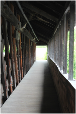
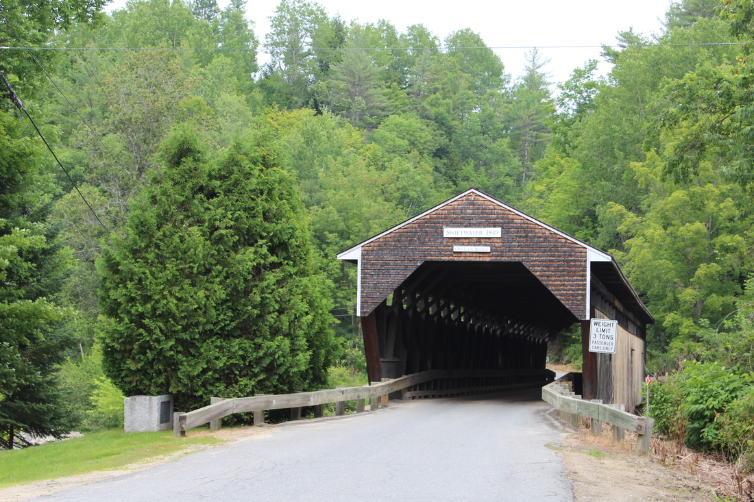
Swiftwater Bridge
Picture
Picture
Picture
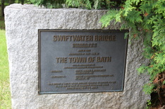
This bridge is the fourth to cross the Wild Ammonoosuc River at this site. The first was built in 1810. It was carried away in 1818 by a flood and replaced in the same year. Again, the bridge was destroyed by a flood in 1828. The third bridge was erected in 1829 and remained at the site until 1849. At that time it was dismantled and replaced by the current bridge. This bridge was rebuilt by the state in 1977 at a cost of $34,347. The rebuilding costs were shared by the state and town. This section of the river was used to float logs to the sawmill. Often log jams presented a hazard to the bridge. In one case, dynamite was used to break up a log jam and although the blast was successful, logs had to be removed from the roof of the bridge. The Swiftwater Bridge is listed on the National Register of Historic Places.


Information taken from

New Hampshire Covered Bridges
Compiled and edited by
Richard G. Marshall
Chief System Planning
New Hampshire Department of Transportation
Color photographs by Arthur F. Rounds
1994


Powered by Create your own unique website with customizable templates.